Leave to the Miistakis institute to be the first people to ask for help finding the places where there aren’t enough beavers. No I’m not kidding.
Citizen scientists recruited as dam detectives to pinpoint beaver homes from satellite images
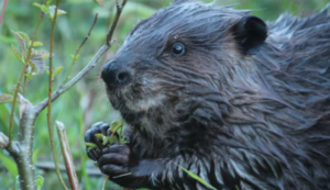 The Miistakis Institute and the Alberta Riparian Habitat Management Society are asking citizens to become dam detectives and find beaver homes from satellite images.
Using Zooniverse, an online research platform, citizen scientists can help determine where beavers are present or absent on the landscape — which in turn will help guide the selection of restoration sites and improve the overall health of streams in southern Alberta.
“We’re kind of looking for those spots where beavers aren’t currently building dams,” said Miistakis Institute conservation analyst Holly Kinas.
“So maybe we can come in and kind of support them by restoring those stream sections and then beavers can move back in and take over that work for us.”
How lovely is that? We need more beavers and more dams in more streams. And more people [ike H0lly Kinas!
Amy McLeod, who is a riparian specialist with the Alberta Riparian Habitat Management Society, calls beavers ecosystem engineers. The animals have helped shape North America’s rivers and streams, she says.
When beavers build their dams they change the flow of water. In instances of flood, researchers have seen that dams delayed the peak of a flood event, buying time for those downstream. But their dams can also act as what McLeod calls speed bumps, slowing down water so it has a chance to stay on a landscape and seep into the ground — which helps with drought and water scarcity.

“I would say that beaver or beaver mimicry is, you know, one of I think, the most useful climate adaptation strategies for us, particularly in southern Alberta, where we’re experiencing water scarcity,” said McLeod.
Kinas said they want to do more of this work, but finding the ideal spots for similar people-made dams is labour-intensive. So why not let beavers lead the way from space?
Water scarcity fixed by beaver abundance. That’s the way it should be.
In each satellite image, a 250-metre area, the user checks for beaver dams and lodges and reports back. Each image is inspected by at least eight users so that the data isn’t just coming from a single source. Users record how many dams they see and whether or not they can spot water in the image.
“We have over 30,000 images that need to be classified,” Kinas said.
Can I get an amen? Go here to start your searches.
